Pilot Calls Mayday as Learjet Plunges 27,000 Feet to Kill Nine in Palm Beach County
A private jet bound for the Bahamas lost altitude rapidly in heavy weather, crashing near a busy road in Greenacres and forcing about 600 residents to leave their homes.
By Sakura Novak ·
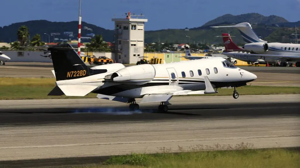
A Learjet 60 business jet crashed into a residential neighborhood in Palm Beach County, Florida, on Sunday, November 1, killing all nine people on board. The aircraft descended from 35,250 feet to 8,750 feet in roughly one minute before striking the ground near Military Trail. U.S. Transportation Secretary Sean Duffy described the event as a horrific tragedy in a social media post. The Federal Aviation Administration confirmed the crash occurred at approximately 12:50 p.m. Eastern time. The jet had departed Austin-Bergstrom International Airport in Texas and was en route to North Eleuthera Airport in the Bahamas.
The National Transportation Safety Board is leading the investigation into the crash. NTSB officials announced they were dispatching a go-team to the site. Investigators were expected to arrive on Sunday and the morning of Monday, November 2. The agency planned to hold a media briefing in West Palm Beach on Monday. No cause for the crash had been determined as of Sunday evening. The FAA is sending a team to the scene to support the NTSB's investigation.
Officials had not released the names of the victims or the specific breakdown of passengers and crew. Jim Reynolds, a spokesperson for Austin-Bergstrom International Airport, stated that the jet was a private aircraft. He said the airport could not identify who was on the flight. Reynolds called the event a definite tragedy. The Palm Beach County Sheriff's Office placed the crash site in Greenacres, a city with a population of approximately 45,000. The site is located roughly seven miles southwest of West Palm Beach.
The crash occurred near Military Trail, between Cresthaven Boulevard and 10th Avenue North. The location is about four miles south of the airport in West Palm Beach, which was renamed President Donald J. Trump International Airport earlier this year. Florida Governor Ron DeSantis visited the crash site. He told reporters that the crash appeared cataclysmic. DeSantis said the jet looked like a missile falling from the sky. He noted that the impact left a large crater on the side of the road. DeSantis said there were no reports at the time of his news conference of anyone on the ground being killed or injured. The debris field stretched a significant distance from the impact point.
Witnesses captured video of the jet descending rapidly. Footage from vehicles nearby showed the plane striking near the roadway and exploding. Flames surrounded chunks of pavement near the crater. The impact site was feet from homes and inches from passing vehicles. Thick black smoke covered the area. Video from WPBF showed the road surface buckling where the jet hit. Anthony Blackmon, a resident about 500 feet from the crash, said debris hit his house. He reported that everything was on fire and the road was burning. Blackmon said he had never expected such an event to happen so close to his home.
Roger Forcelle, a nearby resident, felt the aircraft pass over his home. He said the house shook and the jet crashed less than half a mile away. Neighbors emerged from their homes after feeling the vibrations. Andrew Mannino said that he heard and felt a boom. The power went out immediately in his area. He smelled smoke and saw a large black cloud rise. Another witness described the aftermath as looking like a meteor had struck the ground. A woman working nearby reported that the electricity had been out for about two hours.
About 600 residents in a nearby mobile home community had to leave their homes on Sunday night. The crash scene blocks the entrance to the mobile home park and is being treated as a crime scene while federal investigators work, county officials said. No official has alleged that a crime took place. Palm Beach County Commissioner Joel Flores, who represents District 3, was the first county official at the scene. Flores said residents were being sent to two county shelters. He emphasized the need to ensure shelter for the approximately 600 displaced residents. The Red Cross stood by to assist. Palm Tran buses were ready to transport residents once law enforcement allowed the evacuation.
Palm Beach County closed Military Trail between 10th Avenue North and Purdy Lane/Alameda Drive until further notice. The road remained open only to emergency vehicles. The county directed drivers to use 10th Avenue North and Purdy Lane/Alameda Drive for east-west travel. For north-south travel, officials recommended Haverhill Road and Kirk Road. A county commissioner warned that parts of the road could remain closed for an extended period due to the crater. The timeline for reopening depends on the federal investigation.
Air traffic control recordings and flight tracking data provide details on the final moments of the flight. The jet was flying east at approximately 35,000 feet when pilots reported turbulence, icing, and precipitation. The crew requested to climb 2,000 feet. Minutes before the crash, the pilot told the Miami Air Route Traffic Control Center that they were experiencing light, clear ice that was manageable. The pilot also reported moderate turbulence. The outside air temperature was recorded at minus 47 degrees Celsius. Turbulence caused the jet to bounce by as much as 700 feet.
After the precipitation report, the descent rate increased rapidly. The pilot radioed: "We're descending 8,000, mayday, mayday, we're descending 10,000 feet per minute." The aircraft entered an overspeed condition while descending at 20,000 feet per minute. The pilot stated that the jet was going to crash into the ground. CBS News reported that the pilot also said the crew was out of time. The descent rate reached as high as 30,000 feet per minute. This pushed the jet beyond its design limits. The plane banked sharply to the right before hitting the ground at a steep angle.
The FAA data showed the jet fell from 35,250 feet to 8,750 feet in one minute. Flight tracking site ADS-B Exchange recorded a drop of 27,000 feet in about a minute before the data cut off. Scattered storms were present in the area. The jet passed through a stronger storm cell a few minutes before the descent began. The FAA had issued a convective SIGMET for the area, warning of thunderstorms that threaten aircraft. Whether the weather played a role in the crash has not been determined. Heavy rain fell across the region on Sunday. The National Weather Service had a flood watch in effect through Monday afternoon.
In January 2024, the NTSB issued a safety alert regarding in-flight icing. The alert warned that ice can make managing the airplane's flightpath and airspeed more difficult. It can also prevent the airplane from maintaining level flight. Mary Schiavo, a CNN aviation analyst and former inspector general of the U.S. Transportation Department, said dashcam video would be important to investigators. She stated that the descent was not controlled. She concluded that the crew had lost control of the plane. Schiavo noted that the steep dive could have torn parts off the aircraft. A flight recorder could have been destroyed in the explosion.
It is not known whether the jet carried a cockpit voice recorder. FAA rules require multi-engine jets to carry a recorder only when they are flown for hire. Records show the jet was offered for charter flights. Flight tracking and FAA registry data identify the jet by its registration, N722BD. The FAA registry lists the Learjet 60 as owned by LR60271 LLC of Wilmington, Delaware. CNN reported that the jet is listed online as available for charter. Officials have not stated who operated the Sunday flight.
The crash is the deadliest ever involving a Learjet 60, according to Flight Safety Foundation data. In 2008, four people were killed when a Learjet 60 bound for Los Angeles crashed on takeoff in Columbia, South Carolina. NTSB records show this is the second deadliest crash in the United States this year. A skydiving plane crash in Butler, Missouri, in June killed 12 people. Learjet, the brand made famous by Bill Lear in the 1960s, was most recently built by Canadian manufacturer Bombardier. Bombardier stopped making new Learjets in 2021 but continues to support the planes in service.